NOTE:

This blog is maintained as an effort to coordinate and collocate responding agencies' information for easier public access during events on the Kenai Peninsula. The information here is written and provided by the contributing agencies. NOTE: The blog will be updated as the need arises and may be dormant at times.

Sunday, June 30, 2019

6/30/19 SWAN LAKE FIRE MORNING UPDATE

For Information call: (208) 391-3488
For a pdf version of this update that you can print or email, click here.


On a hot Saturday, firefighters and the Sterling community saw their fire lines tested north of the Sterling Highway and Homer Electric transmission line as fire activity picked up.  Sunday will be another test.  Also along the south side of the Swan Lake Fire, crews mopped-up and started suppression repair work for restoration of wildlife habitat on the refuge.  Heavy equipment operators fixed road damage, improving future access on Mystery Creek Road.

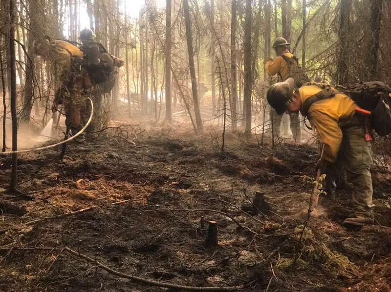
Fire crews along the East Fork Moose River continued to burnout pockets of dead trees and mop up. In the muskeg along Moose River in the Kenai National Wildlife Refuge, crews kept mopping up the burn scar of the 2017 East Fork Fire, which has left a heavy load of dead and down trees, securing this perimeter.  

Hotshot firefighters finished work Saturday for point protection of the Moose Research Center, and made progress guarding public use cabins and ENSTAR gas pipeline infrastructure.  The Swan Lake Fire keeps slowly moving northeast, burning through thick black spruce stands.

Traffic moved well on Saturday along the Sterling Highway, with only minor delays due to restarted road construction and morning fog.  Please use lights and caution driving along the highway in the fire area, as firefighters and construction workers are working along the road.   A night crew will be patrolling and monitoring for smoke and flare-ups.  If conditions deteriorate due to nighttime inversions, traffic delays may be possible.

Smoke and haze conditions on the Kenai Peninsula are expected to linger until Monday, when a cold front is forecast to pass to the north.  Coastal areas should see clearer skies as sea breezes help disperse the smoke.  

The Swan Lake Fire has continued to burn in a mosaic pattern, removing hazardous black spruce and providing for a more fire-resilient landscape for the future.  Fire crews completed work June 28 to improve safety along the Sterling Fire Break.  To enhance community-wide safety, residents should remove needles from roofs and flammable vegetation from around buildings.  This is one of the best ways to better protect your home from fire.  For information about other steps you can take to increase defensible space around your property, please visit http://forestry.alaska.gov/fire/firewise.

An interactive fire map can be found under Current Situational Reports on the Kenai Peninsula Borough emergency blog at http://www.kpboem.com. Map includes fire perimeter and land ownership overlaid on aerial photos.

WEATHER: Conditions will continue to be very warm and dry, with light winds.  Smoke will hang around Sunday.  Slightly cooler temperatures are forecast Monday as a cold front moves through to the north. High pressure over the peninsula will return later next week, returning to hot and dry conditions.

SAFETY: For current road conditions visit http://511.alaska.gov. The Temporary Flight Restriction (TFR) over the fire area includes the Sterling Highway corridor to support suppression efforts and firefighter safety. Pilots can confirm the current TFR restrictions at tfr.faa.gov. Personal drone operations are not permitted on the refuge.

KENAI NATIONAL WILDLIFE REFUGE INFORMATION: The Skilak Wildlife Recreation Area is closed to public use, including campgrounds, trails and cabins. Skilak Lake Road, along with Jim’s, Upper and Lower Skilak landings remain open. Contact the Refuge Visitor Center at 907-260-2820 or online at kenai.fws.gov.


For a pdf version of this map that you can print or email, click here


For a version of this fire progression map that you can print or email, click here


Saturday, June 29, 2019

6/29/19 SWAN LAKE FIRE MORNING UPDATE

For Information call: (208) 391-3488 or (907) 262-INFO
For a pdf version of this update that you can print or email, click here


On Friday, firefighters strengthened and reinforced fire lines along the Sterling Highway and East Fork Moose River.  In the muskeg area of the Moose River in the Kenai National Wildlife Refuge, crews are mopping up the burn scar of the 2017 East Fork Fire, which has left a heavy load of dead and down trees, securing the perimeter.  

A hotshot crew had been repositioned to assist protection of infrastructure along the ENSTAR gas pipeline, public use cabins and the Moose Research Center.  The Swan Lake Fire has been slowly progressing to the northeast and continues to work through thick black spruce stands toward Cook’s Inlet.     

Traffic along the Sterling Highway has resumed two-way movement for the beginning of the holiday week.  Please use caution driving along the highway in the fire area, as firefighters are working along the road.   A night crew will be patrolling and monitoring for smoke and flare-ups.  If conditions deteriorate due to nighttime inversions, traffic delays may be possible.   

Smoke and haze conditions on the Kenai Peninsula are expected to remain for the next few days.  A high pressure system over the area is keeping smoke from moving away until Sunday or early Monday as a front moves in.  People who are sensitive to smoke may want to stay near coastal areas if possible, as sea breezes help disperse the smoke.   

Crews completed work Friday improving the Sterling Fire Break.  The fire has continued burn in a mosaic pattern, removing hazardous fuels and providing for a resilient, healthy, more fire-resistant landscape for the future.   To enhance community-wide safety, residents are encouraged to remove needles from roofs and flammable vegetation from around buildings.  This one of the best ways to improve protection for your home.  For information about other steps you can take to increase defensible space around your property, please visit http://forestry.alaska.gov/fire/firewise. 

An interactive fire map can be found under Current Situational Reports on the Kenai Peninsula Borough emergency blog at http://www.kpboem.com. Map includes fire perimeter and land ownership overlaid on aerial photos. For Kenai emergency information, please contact the Kenai Peninsula Borough Office of Emergency Management call center at 907-262-INFO (4636) between 8am and 8pm.   

WEATHER: Conditions will continue to be warm and dry, with very light winds 5-6 mph.  High pressure and a later inversion break will cause smoke to hang around for the rest of the day.  Cooler temperatures and slight chance of thunderstorms are expected Sunday as a change in weather is forecast. High pressure over the peninsula will return next week, returning to hot and dry conditions. 

 SAFETY: For current road conditions visit http://511.alaska.gov. The Temporary Flight Restriction (TFR) over the fire area includes the Sterling Highway corridor to support suppression efforts and firefighter safety. Pilots can confirm the current TFR restrictions at tfr.faa.gov. Personal drone operations are not permitted on the refuge. 

 KENAI NATIONAL WILDLIFE REFUGE INFORMATION: The Skilak Wildlife Recreation Area is closed to public use, including campgrounds, trails and cabins. Skilak Lake Road, along with Jim’s, Upper and Lower Skilak landings remain open. Contact the Refuge Visitor Center at 907-260-2820 or online at kenai.fws.gov.


For a version of this map that you can print or email, click here 


For a version of this fire progression map 
that you can print or email, click here. 


Friday, June 28, 2019

6/28/19 2:00 PM The Swan Lake Fire Will Burn For Awhile

Great work has been done on the Swan Lake Fire to ensure it didn't harm homes or people in Sterling and didn't cross the Sterling Highway or damage the high transmission line. But it would be an error to look at "percent containment" as a measure of the team's success.

The objective has never been to contain 100% of the fire. Only about 28% is slated for containment. If that 28% is the "new" 100%, then 20% of it has been contained as of today and its all on the Sterling side. But that means much of the fire continue to burn and will be monitored and allowed to continue improving habitat, building a healthier forest and creating a safe fuel break for the future. The fire will eventually go out naturally or when adverse weather puts it out. Borough Emergency Manager Dan Nelson explains more.


6/28/19 10:45 AM SWAN LAKE FIRE MORNING UPDATE

For Information call: 208-391-3488 or 262-INFO


Start Date: 06/05/2019
Location: 5.5 Miles NE of Sterling, AK
Cause: Lightning
Fire Size: 56,200
Containment: 20% (above is an incorrect number. This is correct)
Total Personnel: 530

For an emailable, printable PDF of this update click here:

Crews worked along natural barriers Thursday to complete the burnout operation along the Sterling Highway and the East Fork Moose River. Firefighters are working along the Sterling Highway achieving a 20-25 feet wide cold line perimeter. Once this is completed, and the line strengthened in coming days, it will protect Sterling and the highway corridor. Contingency crews are also improving the Sterling Fuel Break.

A Wildland Fire Module, which specializes in protecting values at risk and monitoring fire behavior has been deployed to prep the Trapper Joe Public Use Cabin to the northwest of the fire. This area is 15 miles north of the Sterling Highway toward the Cook Inlet. They are also working to protect valves along the ENSTAR gas pipeline and the Moose Research Center. The fire has crossed the Chickaloon River and continues to move through thick stands of black spruce toward the northeast away from communities and highway.

Two-way traffic has resumed on the Sterling Highway, with an area of reduced speed between mileposts 65 and 75. However, nighttime inversions may cause areas of low visibility during evening and morning hours resulting in use of pilot cars and flaggers. Night shift resources are assigned to monitor smoke impacts and help ensure public safety along the highway. Firefighters ask the public’s cooperation in keeping speeds low and maintaining awareness.

The Swan Lake Fire is a good example of how burned areas can provide protection from future large fire growth. In the southwest area of the fire, the 2017 East Fork Fire burn scar has slowed the fire’s spread near Sterling. In the Kenai Wilderness area, the burn scar from 2001 is naturally slowing fire growth along slopes of the Kenai Mountains on the eastern edge of the fire. Other areas where refuge fire managers have completed fuel reduction projects are also helping protect neighboring communities.

Residents are encouraged to sign up for KPB Alerts, a local notification system that rapidly conveys important information to the community. Text “KPB” to 99411 to receive a link to sign up on a mobile device.

More information about fire prevention can be found at Firewise.org, Alaska.gov/fire/firewise or Wildland Fire - Ready Set Go! Program.

An interactive fire map can be found under Current Situational Reports on the Kenai Peninsula Borough emergency blog at www.kpboem.com. The map includes fire perimeter and land ownership overlaid on aerial photos. The blog has many other links for fire information as well.

The Kenai Peninsula Borough Office of Emergency Management call center can answer questions about the road and the fire at at 907-262-INFO (4636) between 8am and 8pm. The call center will close for good Saturday at 5:00 pm. Or go to the Kenai Peninsula Borough Facebook page.

WEATHER: Conditions will continue to be warm and dry, with today being the hottest day. Winds are expected to be light and variable over local terrain. Tomorrow will be similar to today.

SAFETY: For current road conditions visit http://511.alaska.gov. The Temporary Flight Restriction (TFR) over the fire area includes the Sterling Highway corridor to support suppression efforts and firefighter safety. Pilots can confirm the current TFR restrictions at tfr.faa.gov. Personal drone operations are not permitted on the refuge.

KENAI NATIONAL WILDLIFE REFUGE INFORMATION: The Skilak Wildlife Recreation Area is closed to public use, including campgrounds, trails and cabins. Skilak Lake Road, along with Jim’s, Upper and Lower Skilak landings remain open. Contact the Refuge Visitor Center at 907-260-2820 or online at kenai.fws.gov.

6/28/19 9:00 am FIREWORKS USE SUSPENDED

6/28/19 9:00 am FIREWORKS USE SUSPENDED

For an emailable, printable PDF of this update, click here


For Immediate Release                                                                                                 DPS PR# 19-018

Fireworks Use and Sales Suspended Over Much of the State
Decision based on hot, dry weather and “high to very high fire danger”

June 27, 2019 (ANCHORAGE) – The Alaska State Fire Marshal’s Office, in cooperation with the
Alaska Department of Natural Resources / Division of Forestry, is implementing an immediate suspension on the sale and use of fireworks across much of Alaska. Made in accordance with Alaska Administrative Code 50.025 Fire Code, the suspension will remain in effect until further notice and includes the following areas:
  • Fairbanks North Star Borough
  • Kenai Peninsula Borough
  • Matanuska-Susitna Borough
  • Kodiak Borough
  • Copper River Valley, including Glennallen south to Valdez
  • Western Alaska, including McGrath and points west
  • Tanana Valley north of the Alaska Range
  • Northern Panhandle, including Haines in the north, Skagway, and Juneau to the south

“I’m greatly concerned with the heightened fire danger,” said State Fire Marshal Richard Boothby.
“Our firefighting resources and capabilities on the ground and in the air are stretched thin. That combined with the weather forecast going into next week, the safety of Alaskans and visitors paramount. The suspension of the sale and use of fireworks will assist in protecting life and
property.”

In its request to the State Fire Marshal for the suspension, the State Forester’s Office cited “high to very high fire danger across most of the state, expected dry and hot weather, 90-degree highs possible … with a shortage of firefighting resources in the state.” According to the Division of Forestry, 102 uncontained fires are burning in Alaska with a total of 273,551 acres burned. Two notably large fires currently under management of Alaska Type 2 Incident Management teams include the Swan Lake fire on the Kenai Peninsula, staffed with 511 personnel, and the Shovel Creek fire outside of Fairbanks staffed at 245 personnel.

The Alaska Wildland Fire Coordinating Group (AWFCG) is the interagency management entity that allocates statewide resources as fire activity and resource shortages occur. Fire activity is at a Planning Level 4 and the AWFCG has stood up a Multi-Agency Coordinating Group in preparation for a significant increase in wildfire activity statewide. For wildfire updates and fire safety information, visit:

###
For more information, contact Public Information Officer Ken Marsh at ken.marsh@alaska.gov
or phone (907) 269-5654.

6/28/19 9:00 am NEW MAP OF SWAN LAKE FIRE

For an emailable, printable PDF of this map, click here:

This is the new map of the Swan Lake Fire - produced Thursday at 4:45 pm. 

Only one map a day is produced. The fire size is now 56,200 acres,  about an 8000 acre increase due to the burnout.

6/28/19 7:30 am Swan Lake Fire Update

Heavy smoke on the Sterling Highway has the road down to one lane and pilot cars working again according to 511 Alerts. This should be temporary until the inversion layer burns off mid morning and the smoke lifts. Be patient and drive cautiously with headlights on

Thursday, June 27, 2019

6/27/19 8:00 PM Swan Lake Fire reaches 56,200 acres at 5:00 pm

Progress was good today on the fire and the remaining burnout went well. The fire was reported at 56,200 acres as of 5:00 pm, mostly due to the burnout operation. Mop up along the highway and the western flank is continuing to ensure no heat remains.

People will continue to see smoke as the islands of fuel away from the highway continue to be consumed and there may be smoke on the Sterling Highway until the inversion lifts mid morning.

With less fuel out front of the fire on at least 3 flanks, the public can expect less smoke in the coming days.  However, since not all the perimeter is planned for containment, the fire will continue to burn east into the Wildlife Refuge creating a healthier and more diverse forest.

Both lanes of the Sterling Highway remain open with a short zone (MP 67 to 75) slowed to 35 mph for the safety of drivers and firefighters. Please use headlights.

The Borough call center will be closed Saturday at 5:00 pm. But until then, people will be there to answer any questions about the fire, from 8:00 am to 8:00 pm .

6/27/19 5:15 PM Media Trip to the Swan Lake Fire

Yukon Crew boss Robert Lacey is interviewed by Channel 11 from Anchorage

Yukon Crew boss Robert Lacey is interviewed by Channel 11 from Anchorage

A member of Yukon Crew works in the Watson Lake Campground

The Yukon Crew works in the Watson Lake Campground

A boat to move firefighters on Watson Lake in front of the Swan Lake Fire

The Yukon Crew works in the Watson Lake Campground

The Yukon Crew works in the Watson Lake Campground

Media taking pictures of the Swan Lake Fire from Watson Lake

The Yukon Crew works in the Watson Lake Campground

6/27/19 5:00 pm Aerial Fire Fighting Drone

This video is from an Unmanned Aerial System (UAS) "drone" operated by @BLM Alaska Fire Service UAS Pilot, Jo Don Morton and #LakeviewHotshots Drone Pilot, Milton Truong. This drone was utilized for missions on the #SwanLakeFire.

In addition to aerial video and infared reconnaissance, this drone is outfitted with a Plastic Sphere Dispenser(PSD) to support hand crews on the ground during firing operations.


6/27/19 1:30 PM Sterling Highway UPDATE

Both lanes of the Sterling Highway remain open. The posted 35 mph section is from milepost 58 to milepost 75.5 and IS being enforced by Alaska State Troopers. Visibility as of 12 noon was only 500 to 1000 feet between milepost 58 and milepost 67 so drive with caution and have headlights on.

6/27/19 11:45 AM STERLING HIGHWAY HAS BOTH LANES OPEN

After completing burnout operations along the Sterling Highway and confirming the fireline is holding, the Alaska Incident Management team has reopened the southbound lane of the Sterling Highway to traffic.

Both lanes are moving slowly due to a posted 35 MPH speed limit and state troopers are onsite to enforce the speed limit. While fire equipment is off the highway, there are still traffic cones on the northside of the highway, so please drive with caution.

If anything changes with the fire, the lane could be closed again and pilot cars called back so remain aware of the situation for a few days until the team is sure things will hold

6/27/19 10:30 AM Swan Lake Fire Update


Strategic firing operations continued yesterday along the Sterling Highway from Milepost 68, west toward the Watson Lake campground. Unfavorable winds out of the north slowed hand-firing efforts during the morning. Helicopters and drones with Plastic Sphere Dispensing (PSD) machines that drop ping-pong like balls with reactive chemicals inside were used to increase the burned area of the firing operation in front of the main fire.

Firefighters have completed intentional burning along the highway and the Homer Electric Transmission Line this morning using swing shift crews who worked into the early morning hours. Today crews will complete the remaining mile of firing operations northwest between Watson and Afonasi lakes on the East Fork Moose River, helping to protect the community of Sterling.

Motorists can expect traffic delays to continue today along the Sterling Highway. Flaggers and pilot cars will be moving traffic through a single lane along approximately 10 miles of the fire area as firefighters use the lane nearest the fire. Smoke may affect visibility in the afternoon when winds are expected to switch out of the north. Nighttime inversions also may cause areas of smoke and fog. Temperatures in the upper 80’s and low relative humidities will continue into the weekend. The northeast section of the fire continues to grow toward a valve site on the ENSTAR gas pipeline and the Trapper Joe public use cabin. Structure protection crews are preparing the sites in the event fire reaches it.

Preparations include clearing away burnable vegetation and setting up pumps with hose lays and sprinklers. Currently, the fire is held up at the Chickaloon River, but it is expected to continue moving to the northeast over the coming days. The last recorded fire in this area occurred in 1947. Wildland fires typically do not completely burn all of the landscape but move in a mosaic pattern, removing thick black spruce forests. The result will be a healthy, diverse forest in the Kenai National Wildlife Refuge. Reduction of flammable fuels will help protect
neighboring communities well into the future.

Residents are encouraged to sign up for KPB Alerts, a local notification system that rapidly conveys important information to the community. Text “KPB” to 99411 to receive a link to sign up on a mobile device.

More information about fire prevention can be found at Firewise.org, Alaska.gov/fire/firewise or Wildland Fire - Ready Set Go! Program. An interactive fire map can be found under Current Situational Reports on the Kenai Peninsula Borough emergency blog at www.kpboem.com. Map includes fire perimeter and land ownership overlaid on aerial photos. For Kenai emergency information, please contact the Kenai Peninsula Borough Office of Emergency Management call center at 907-262-INFO (4636) between 8am and 8pm.

WEATHER: Warm and dry conditions continue today with winds from the northwest. Maximum temps may reach 87 with relative humidity decreasing as a high pressure system sets up over the fire area.

SAFETY: For current road conditions visit http://511.alaska.gov. The Temporary Flight Restriction (TFR) over the fire area includes the Sterling Highway corridor to support suppression efforts and firefighter safety. Pilots can confirm the current TFR restrictions at tfr.faa.gov. Personal drone operations are not permitted on the refuge.

KENAI NATIONAL WILDLIFE REFUGE INFORMATION: The Skilak Wildlife Recreation Area is closed to public use, including campgrounds, trails and cabins. Skilak Lake Road, along with Jim’s, Upper and Lower Skilak landings remain open. Contact the Refuge Visitor Center at 907-260-2820 or online at kenai.fws.gov.

6/27/19 10:15 AM Sterling Highway Update

The Sterling Highway remains open with delays and pilot cars as crews finish the burnout along the highway. When that is done, its expected that both lanes will open again and there will be no more pilot cars. Until then, plan for delays with extra supplies and drive with caution.

6/27/19 Morning map of the Swan Lake Fire

This is the June 27th map of the #SwanLakeFire. Maps are only created once per day. The fire is flown late in the evening by aircraft with infrared cameras or by satellite, then the data is downloaded and a map is created for use the next morning. This perimeter is from a flyover at 10 pm last night so does not include the firing operations work done late last night along the highway and along the East Fork of the Moose River . FOR A EMAILABLE, PRINTABLE PDF OF THIS MAP, CLICK HERE

Wednesday, June 26, 2019

6/26/19 7:30 pm Sterling Community Meeting is Over

About 125 to 150 people showed up at tonight's public meeting at the Sterling Community Center.

All seemed to go well with most of the questions focused on the remaining threat from the fire, about the traffic issues, the good being done by the fire and when it might be over.

The meeting was live streamed on the DNR Alaska Division of Forestry Facebook page and the recording will remain available on that site if you were not able to attend or watch live.

6/26/19 5:00 PM Emergency Manager Dan Nelson on KPB Alerts

The Borough Emergency Manager Dan Nelson says the Swan Lake Fire is the perfect reminder to sign up for emergency messages from KPB Alerts. Do it on your mobile phone by texting KPB to 99411.


6/26/19 COMMUNITY MEETING TONIGHT

6/26/19 2:45 pm
Don't forget there is a community meeting tonight at 6:00 p.m. at Sterling Community Center. The Incident Management Team and other partners and cooperators will be there to answer your questions

6/26/19 Swan Lake Fire NOON UPDATE

Firing operations have begun again along the Sterling Highway, starting at Milepost 68 and heading west toward the Watson Lake area on the East Fork of the Moose River.
Motorists should expect pilot cars to continue escorting vehicles past the firing operation and all the fire equipment but there will be delays as they are using only one lane. Skilak Lake Road is open for use with the exception of RV's, 5th wheels and semi's.

6/26/19 10:00 AM Swan Lake Fire Update

FOR A PRINTABLE, EMAILABLE PDF OF THIS UPDATE, CLICK HERE
FOR A PRINTABLE, EMAILABLE PDF OF THE MAP, CLICK HERE

Fire crews conducted a strategic fire operation yesterday north of the Sterling Highway and the Homer Electric Transmission line. Utilizing aerial ignitions and ground support, firefighters took advantage of favorable conditions to establish a control line and draw the fire near the road system away from the Sterling Highway and into areas away from critical infrastructure.

Burnout Operation Tuesday evening. Right end
is along the Sterling Highway. Firing Operations
will continue today.
Crews worked through the night and successfully burned to milepost 68 and will continue to the west
today. Firefighters strengthened containment lines along the southwestern edge of the fire as they worked on mop-up and prepared areas near the East Fork Moose River for burnout operations. Along the northeastern perimeter, firefighters implemented structure protection plans to protect public use cabins and Enstar Natural Gas infrastructure in that part of the refuge.

Motorists can expect traffic delays today as fire operations continue. Flaggers and pilot cars will be moving traffic through a single lane along sections of the highway as fire apparatus will be using one full lane for their operations. As hot and dry conditions increase, firefighters are working hard to coordinate efforts along the Sterling Highway. Aerial resources will continue to support efforts to secure the fire’s edge where fire growth is not desirable. Fire crews are providing 24 hour coverage. A night crew will patrol lines and evaluate smoke issues along the highway.

The Alaska Management Team is hosting a community meeting Wednesday, June 26, at the Sterling Community Center at 6 pm. Incident command staff will be on hand to provide fire information and to share the strategies and tactics being used to protect critical infrastructure throughout the community. All residents are welcome to attend and ask questions about this incident and to learn about the steps being taken to protect the community and critical infrastructure.

Residents are encouraged to sign up for KPB Alerts which is a Kenai Peninsula Borough notification system that rapidly conveys information to the community. Residents can text “KPB” to 99411 to receive a link to sign up on their mobile device. More information about fire prevention can be found at Firewise.org, Alaska.gov/fire/firewise or Wildland Fire - Ready Set Go! Program. An interactive fire map, made by the Kenai Peninsula Borough and available for residents, can be found under Current Situational Reports on the KPB emergency blog at www.kpboem.com. Those accessing the map will find the fire perimeter as well as the land ownership parcels in the Sterling area. This makes it possible to see the distance between the fire and residential areas.

For Kenai emergency information, please contact the Kenai Peninsula Borough Office of Emergency Management call center at 907-262-INFO (4636) between 8am and 8pm.

WEATHER: Hot and dry conditions will increase today with winds from the northwest and the north by midday. An air quality advisory continues through Friday, June 28.

SAFETY: For current road conditions visit http://511.alaska.gov. The Temporary Flight Restriction (TFR) over the fire area includes the Sterling Highway corridor to support suppression efforts and firefighter safety. Pilots can confirm the current TFR restrictions at tfr.faa.gov. Be advised that personal drone operations are not permitted on the refuge.

KENAI NATIONAL WILDLIFE REFUGE INFORMATION: The Skilak Wildlife Recreation Area is closed to public use, including campgrounds, trails and cabins. Skilak Lake Road, along with Jim’s, Upper and Lower Skilak landings remain open. Contact the Refuge Visitor Center at 907-260-2820 or online at kenai.fws.gov.

6/26/19 9:30 am UPDATE on Swan lake Fire

Good news! The pilot cars are again moving on the Sterling Highway. However, the smoke and marine layer will remain an issue so please drive cautiously.

THERE IS A COMMUNITY MEETING AT STERLING COMMUNITY CENTER AT 6 P.M.
(Click here for a PDF of the meeting flyer: https://drive.google.com/open?id=1nT6heVQvwYC7IzZt5rap6_Kql-2JLmFn)

The Highway remains at one lane with pilot cars, so expect and plan for potentially hours long delays again today, so bring water and snacks. Flying might a possibility but flights are filling up. In addition, if the fire behavior increases and fire operations have a problem, traffic could be temporarily stopped until the emergency is over so, at times, delays could be longer.

This is the burnout last night. Looking west toward
Mystery Creek Road and then curved along the
Sterling Highway
Last night's burnout operations went to midnight last night and went well. Line has been burned from east of Mystery Creek Road to about MP 69. Those firing operations will continue today down the East Fork of the Moose River and again along the highway to Watson Lake


6/26/19 8:00 am UPDATE STERLING HIGHWAY NOT MOVING

The predicted heavy smoke is laying in over the Sterling Highway about milepost 62 to 72.  That smoke combined with the marine fog has made it impossible for the pilot cars to operate so nothing is moving.  The cars will start moving traffic as soon as the smoke and fog lift and its safe to do so.  Even after that, the burnout along the highway will be continuing for the next few days which will mean traffic delays. Please plan accordingly and bring drinks and snacks.

Tuesday, June 25, 2019

6/25/19 8:15 pm UPDATE on Swan Lake Fire

A last heads up - heavy smoke is expected in Cooper Landing tonight and tomorrow.  Those driving should have headlights on all time and drive cautiously. Those in Cooper Landing should be cautious that it will likely be very heavy until the inversion burns off.

6/25/19 7:00pm UPDATE ON THE SWAN LAKE FIRE

Traffic is still backed up on the Sterling Highway due to Swan Lake Fire activity and fire equipment working near the highway. However, there are reports that things are moving with pilot cars.
The incident Meteorologist says there is a good chance most of the smoke from today will lie low around Cooper Landing tonight and in the morning so plan accordingly. Always drive with headlights on in smoky conditions
Below are pictures of what's been going on near the road to give you a better idea of what is causing the delay.

Smoke along the Sterling Hwy during the burnout

Helicopters dropped water when the fire threatened to cross the highway

Firefighters work prepping for firing along the Sterling Highway

Helicopter making a drop

Flames go up north of the powerline due to burnout operations

6/25/19 6:15 pm Update on the Sterling Hwy

Traffic on the Sterling Hwy, heading both into and out of town, is worse than ever this evening. In addition to the more than 90 minute expected delays, there has been some fire activity near the road that required holding even pilot cars for a time.
Please be aware that this can happen due to the unpredictable nature of fire and is both unexpected and unavoidable. Plan for long delays for today and perhaps the next few days.

6/25/19 5:00 pm UPDATE on the Swan Lake Fire

6/25/19 5:00 PM UPDATE
This photo, take by emergency Management Director,
Dan Nelson, is looking toward Cooper Landing from
Milepost 72, just before Watson lake.
Traffic continues to be delayed along the Sterling Hwy due to burnout operations on the Swan Lake Fire. Motorists are encouraged to plan for delays and bring extra water and snacks since some delays are more than 90 minutes. The delays are related to firefighters working near the edge of the highway and helicopters working overhead so please be vigilant and careful as you drive.

Please stay tuned to the Borough Facebook page or website www.kpboem.com for information or call our team members answering phones at 262-INFO